Wednesday, August 28, 2024

History right at our feet


If you're not an archaeologist, this is just junk

Ferryland, a small village a short one-hour’s drive south of St. John’s, was first visited by French and Portuguese fishermen in the 16th century. (The word Ferryland likely comes from the Portuguese word farelhão, meaning ‘small promontory’.) It was colonized by the British in 1623 and was the first capital of Newfoundland. Today, the area is home to the Colony of Avalon, a historical museum and active archaeological site.

We arrived at the museum just in time to join an excellent guided tour of the archaeological site, where we not only learned about the history and historical significance of the area, but watched (and even met) the archaeologists working on the site. For me, whose dreams of being an archaeologist were dashed when I was diagnosed with arthritis in my late teens, this was the next best thing!

Just a small part of the archaeological dig at Avalon

It may be the hat, but this archaeologist looks a bit like Indiana Jones!


Looking over the current dig site

Later, we did the 30-minute hike out to the Ferryland Lighthouse, and while we were enjoying the view, we struck up a conversation with a fellow named Billy Doyle (is that not a Newfie name, or what!) after asking him to take our photo. Turns out Billy’s a local, and the uncle of the woman who runs a company called Lighthouse Picnics. He said to us in his lovely Newfoundland accent, “Would you like a tour of the lighthouse keeper’s house?” A private tour of an 1870’s lighthouse keeper’s home? Of course, we said yes! Billy’s niece has leased the old house from the town (with hopes to purchase it outright one day) for her business, and has been slowly renovating the structure. Inside, there is now a commercial kitchen, but the rest of the house is still in (mostly) original condition – even down to the original floors. And all the while, Billy provided fascinating commentary on the history of the house, as well as how his niece has upgraded the house, and her hopes and plans for the future use of it.


The Ferryland Lighthouse

Inside the lighthouse keeper's home

It certainly pays to strike up a conversation with a stranger. Thanks for the tour, Billy!

St. John's, you deserve more than that


A view of St. John's and the harbour from Signal Hill

Although St. John’s was on our list of places to visit in Newfoundland, our main reason to make the trip to the capital and largest city in NL was to get new tires on the RV. After driving some rough roads, one of our tires had developed an odd wobble and needed to be replaced. Of course, the only tires available to fit the RV were in St. John’s. 

Once we got that out of the way, we stayed a couple extra days to see the sights. Well, admittedly, we only saw two sights. We did not visit the quaint fishing village of Quidi Vidi, we did not go to Bowring Park, or the Cape Spear Lighthouse, or visit the bars and pubs on George Street.

We did however drive the winding road through the Battery up to Signal Hill, and we did wander the criss-crossing streets (passing colourful jellybean row houses) on our way to The Rooms. We toured the visitor centre at Signal Hill and then hiked to the top for the traditional firing of the noon-day cannon. And we spent an entire day walking through The Rooms – Newfoundland and Labrador’s largest museum and art gallery.

Training day for the Signal Hill Tattoo

Cape Spear from Signal Hill

Firing of the noon-day cannon at Signal Hill

Colourful jellybean rowhouses of St. John's

Inside The Rooms

That was enough of St. John’s. We were too exhausted to see any more, so we left the rest for our next visit to the island.

Recommendations rarely fail us


Brigus

Brigus is a picturesque little town located on Conception Bay, just down the road from the town of Cupids, and only 80 kilometres from the capital of St. John’s. One of D’s hockey buddies recommended we visit there, and this recommendation did not disappoint!

The town was founded in 1612 (though oddly not incorporated until 1867) and is one of Newfoundland’s oldest settlements. To our delight, the town has maintained much of its heritage, and the streets are lined with homes dating back to the mid-19th century. Many visitors come to wander the rambling, paved streets (many of which were once meandering dirt-track cow paths) to photograph the lovingly restored homes and buildings like Hawthorne House, Kent Cottage, and the Stone Barn Museum.

Stone Barn Museum build in 1825 was once a doctor's house


This pretty house dates from 1869

St. Georges Heritage church - build in 1876

But one of the most intriguing and photographed sights in Brigus is most likely the Brigus Tunnel. A 30m long pathway leads you through a wall of solid rock from the town directly to a sheltered harbour on the other side. Blasted and drilled in 1860, the tunnel was built for Captain Abraham Bartlett. Bartlett owned a fishing vessel that was much too large to berth in the nearby harbour at Brigus, so he purchased land and hired a local miner to cut a hole in the rock large enough to allow horses and carts to go through with his precious cargo of fish.

Brigus Tunnel

At least, that’s what historians tells us. Local folklore tells a different story, one of rum runners and contraband and a pirate’s treasure. I must admit, standing inside that darkened tunnel, it was easy to imagine seeing the ghosts of those pirates sneaking by with their loot, rather than simply carting Bartlett’s fishy catch into the village.

Saturday, August 24, 2024

No dildos here


No visit to Newfoundland would be complete without a stop in Dildo. We can now say we’ve “been there, done that”, and we even got our Dildo souvenir.

T-shirts, keychains, magnets, but no dildos

How exactly did the town of Dildo get its name? No one really knows for sure, but it’s been called that since at least 1711. Here are three (of the countless numbers of) possibilities:

1. To the early English settlers, the land formation in the area looked like a dildo – a word once used to refer to a phallic-shaped pin that acted as a pivot for the oar of a rowboat;

2. Nearby Dildo Island was originally named De l’ile de l’eau by the French, and over time the name was corrupted and became Dildo;

3. Mariners who were stuck waiting for enough wind to move their boats through the narrow channel called Dildo Run often said they were in the doldrums, or “dilly dollies”, which was eventually shortened to Dildo.

No matter how the town got its name, it still makes me giggle when I say, “We’ve been to Dildo.”


A detour – just for Tickles


John Cabot

One our way to St. John’s we made a detour through one of the more scenic areas of Newfoundland - the Bonavista Peninsula. John Cabot, an early explorer, set foot on land here in 1497, declaring it “O Buona Vista!” Cabot told two people, and they told two people, and so on, and by the early 16th Century, the town of Bonavista, one of the oldest communities in North America, was established.

Across the Bonavista Peninsula, tourists find many scenic locations – and I am pretty sure we stopped at them all. Cape Bonavista Lighthouse, completed in 1843, with its unique vertical red and white painted stripes. Dungeon Provincial Park, where the constant wave action has eroded the land to form an inland depression in the earth. The small town of Elliston, that claims to be the Root Cellar Capital of the World, and home to one of the largest and most photographed colonies of puffins in the province. And Tickle Cove, with its majestic carved rock arch.

Tickle Cove?

We’ve come across the word tickle a lot in Newfoundland – from seeing place names on the map we refer to every night as we plan our next day’s route, to road signs we pass along the way. There’s Tickle Harbour, Leading Tickles, Burnt Island Tickle, and my personal favourite - Pinchgut Tickle. Apparently, there are over 300 place names featuring Tickle in Newfoundland and Labrador.

So, what is a Tickle? The Dictionary of Newfoundland English defines a tickle as, “A narrow salt-water strait, as in an entrance to a harbour or between islands or other land masses, often difficult or treacherous to navigate because of narrowness, tides, etc; a ‘settlement’ adjoining such a passage.” With over 17,000 kilometres of coastline in NL, it’s no wonder there are a lot of tickles.

Well, I’m just tickled that we’ve been able to visit a few of them on this trip, along with all the other beautiful places we've seen.

Cape Bonavista Lighthouse

Looking down into 'The Dungeon'

One of the root cellars at Elliston

Puffins!

Couldn't resist getting a snapshot of this

The arch at Tickle Cove


Gros Morne - Part I


Gros Morne - the mountain the park is named for

Gros Morne National Park lies on the western side of Newfoundland, on the Gulf of St. Lawrence. It is a UNESCO World Heritage Site, with dramatic scenery shaped around 1,200 million years ago by colliding continents and grinding glaciers.

We camped for three nights at a private campground in Norris Point, where we biked, hiked, and ferried our way around the central part of the park – seeing just a tiny slice of the 1,805 square kilometres of land inside this protected area.

Bike and Ferry to Woody Point

Main Street - Woody Point

Hiking the Burnt Hill Trail

View of Neddy Harbour from the top of Burnt Hill

D has a funny saying, which turned out to be not so funny for us. “Why don’t you see any moose in Newfoundland? Because they’re hiding in the potholes!” True, visitors to Newfoundland rarely see these majestic creatures (they are shy, I guess). And true, the potholes can be so large that the moose can actually fit in some of them!

Driving along the highways here in Newfoundland, it can be difficult to miss the potholes since there are so many of them. We may have hit a few too many, and one of our front tires started to develop a strange warble. Concerned that any more potholes may be the death of our good friend Stevie the RV, D looked in to having the front tires replaced. Turns out the only ones that would fit Stevie were in St. John’s – clear across the province, 708 kilometres away.

The wonky, warbly tire

So off we went. We’ll save the rest of Gros Morne for later.

Saturday, August 10, 2024

Our first bit of drama(tic)

Driving along the Port au Port Peninsula

I’d heard about the Port au Port Peninsula, a lovely coastal drive along the southwest coast of Newfoundland, just outside of Stephenville. We decided to take the short, one-hour drive to Cape St. George to spend the night at the campground right on the cape.

Sunset at Cape St. George

The views along the coast certainly did not disappoint! Tiny villages hugging the seaside cliffs, crashing blue waves, and soaring birds – seagulls, northern gannets, and kittiwakes – made for dramatic scenes. Even a wedding photo shoot!

Dramatic scenery makes for a beautiful backdrop

Although windy (gusts of over 40km/hr!), our camping spot was right on the edge the cliff overlooking St. Georges Bay – it could not have been any better!

Now that's a camping spot!

A drone's-eye view of Cape St. George and the bay

The next day, after a late breakfast at Tea by the Sea that included Toutons (another post, another day) we completed the circle of Port au Port, stopping along the way at a relatively unknown geological site called Folded Rocks. We found it rather odd that something so significant was only mentioned on a couple websites, and there was absolutely no signage on the road to indicate the location. I’m so glad we found it, thanks to Bob!

The Folded Rocks, with our friend Steve for size comparison


Welcome to 'The Rock'!


There are only two ways to get to the island of Newfoundland – by plane or by boat. We chose the boat route, because you can’t take an RV on a plane.

There are three ferries that take you to Newfoundland:  

• You can drive through Quebec and Labrador - it’s a 41-hour drive to get to Blanc Sablon, the town where the ferry to northwestern Newfoundland departs from;

• Take the seasonal (runs mid-June to September), 16-hour ferry from North Sydney in Nova Scotia to Argentia on the south-western side of the Avalon Peninsula;  

• Or the most popular seven-hour route from North Sydney to Port aux Basques on the south-western side of the island of Newfoundland.

We chose the latter. We booked last-minute, resulting in a longer than expected wait time. Before leaving home, D was told we could likely get on a ferry within three days. I’m glad we decided book earlier – our reservation was for three weeks out! Due to mechanical problems with the brand new (and currently only) ferry that runs from Argentia to North Sydney, travellers have often been re-routed to Port aux Basque, which is an 8-1/2 hour drive from Argentia. One woman recently complained on CBC news that her ferry reservation was cancelled due to mechanical issues on the ferry boat, and was rescheduled… for five days later! Another couple we spoke to recently had said their ferry departed over four hours late. I guess we can’t complain too much about the ferry system in British Columbia, can we?

Fortunately, we were not rescheduled, nor did the ferry leave late. And most importantly (for me) is that the weather was calm, so we had a very comfortable crossing. The only downside was that our ferry departed at 11:45pm, and we were unable to book a sleeping cabin, so slept on the reclining lounge seats with other travellers. D did not sleep well, complaining his neighbours were snoring and farting. I hope he wasn’t talking about me!

Waiting for our ferry to load

Our first impression of ‘The Rock’, the nickname many use for the island of Newfoundland, was just that - rocky. We disembarked and drove up an incline carved out through the barren stone cliffs into an area that made me think we had arrived on another planet, not another province in Canada. Rocks and boulders everywhere. No trees. The flat vista was dotted with small lakes, called ponds. In Newfoundland, just to confuse outsiders, lakes are called ponds, and ponds are also called ponds. The reason for this, I’ve learned, is that in Ireland and Scotland (where many Newfoundlanders’ ancestors originated from) there are very few bodies of fresh water large enough to call a lake, so everything there is called a pond.

In case you’re wondering, rivers, streams, creeks, and waterways in Newfoundland are all called brooks. Newfie speak. Everything in Newfoundland is just a bit different than anywhere else in Canada.

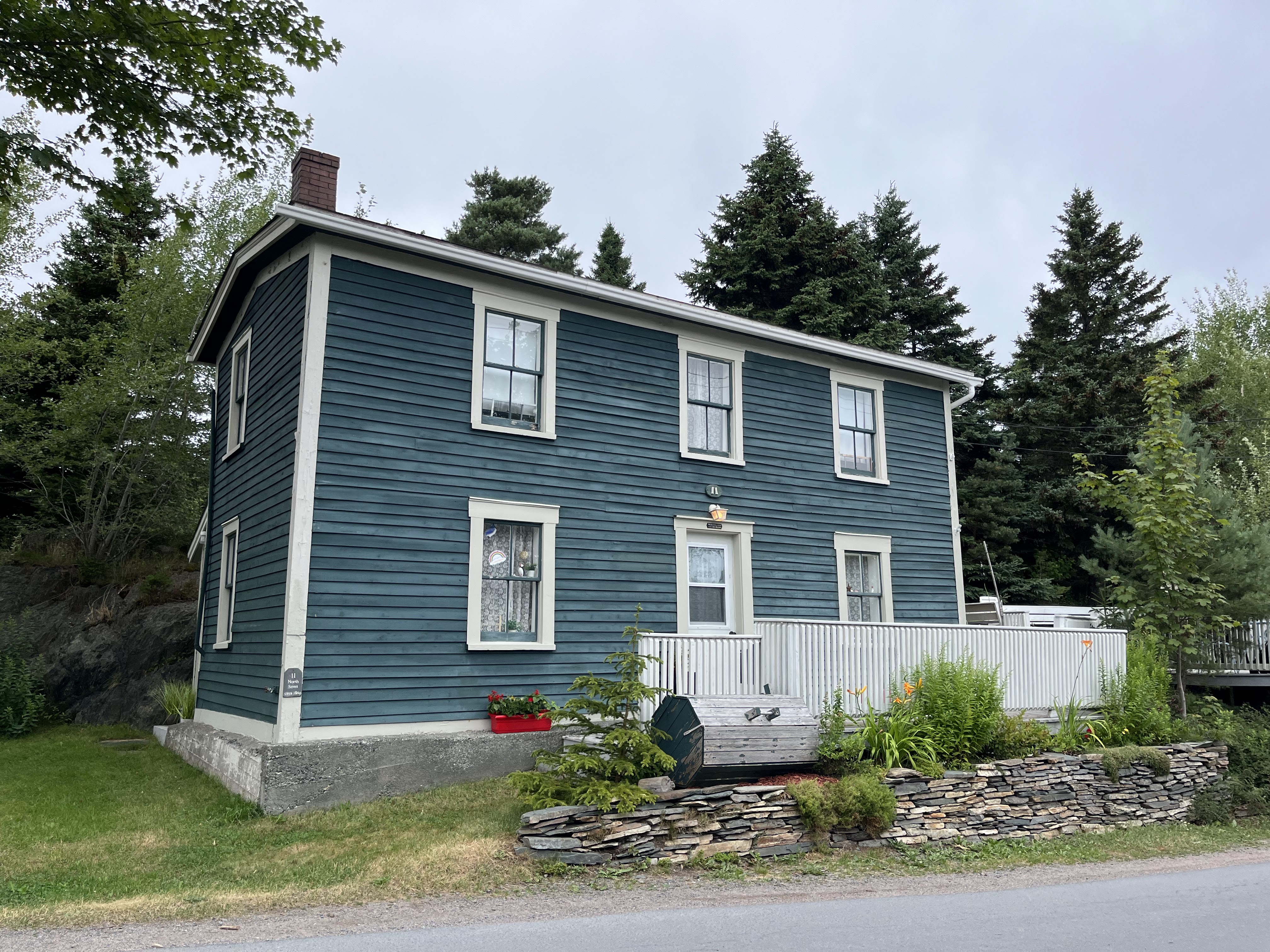
And yes, Newfoundland houses are painted bright colours, just like you see on TV and in magazines. Not all, but many are. I’ve heard numerous explanations, but the one I like most is that after many days at sea, fishermen would get off their boat and head straight to the local pub to celebrate their safe arrival home. They would then stagger up the hill in a drunken state, knowing that the house they had to head towards was the bright red one, or the light blue one, or the sunny yellow saltbox one, and not the “tird white house on da left b’ye.”

Cute story, with maybe just a little truth to it? A more credible story is that fishermen painted their homes bright colours so they could easily be seen through the fog, and stood as cheerful reminders that they were almost home after days away at sea. A comforting thought, that one.

Colourful homes along the bay at Bonavista

Whatever the reason, the small hamlets and villages we pass through each day are delightfully picturesque with their bright, colourful homes dotting the green-gray landscape along the coves and bays. Both D and I have many, many photos so far, and I’m sure plenty more will come as we make our way across the province.


The life of a miner


I think I’ve been pretty lucky. Of all the jobs and careers I’ve had, I’ve never suffered hardships. I’ve never worked outdoors, or in the rain, in the dark, in the cold. I’ve never come home filthy dirty after a day's work. I’ve never been exposed to hazardous materials that could cause illness or death. I’ve never lost a friend or loved one to a workplace accident. The only times I’ve ever come close to any of this is when, as a union member, I had to picket during a strike. But it was summer and the weather was fine, so it really wasn’t so bad.

In Glace Bay in Nova Scotia, the Cape Breton Miners Museum immersed us in the life of a coal miner through the 19th and 20th centuries. We learned of the terrible and sometimes frightening conditions the miners experienced every day, and even after they punched the clock to go home. We toured the re-created Ocean Deeps Colliery (mine shaft) that was quite realistic – right down to the cramped tunnels with little headroom, the water dripping from the ceiling, and the muddy ground you walk on. The power even went out while we were deep in the mine shaft, resulting in complete, almost claustrophobic, darkness. I’m not so sure if the outage was intentional, but it was certainly disconcerting, and I was ever so thankful when the lights came back on seconds later. Our guide though, was not concerned. He only called out to us, “Does everyone have a cellphone with a light?” Likely something he experienced regularly when he worked as a miner.

The guides are all retired miners, with first-hand experience working in the less than optimum conditions that most of us can only imagine. And although the working conditions have greatly improved since the first mines were opened in the area, the personal stories our guide described as we crouched down in the dark, damp, and muddy shaft made me shudder with the thought that people will do anything to make a living, even risk dying, each and every day.

Damn I’ve been lucky.

Entrance to the mine

Getting a little cramped!

Drip, drip, drip

Muddy, muddy!

People worked in these condition??!!